
A Lot About Planning
During the middle of last week, I received instructions on two projects I will be working on this summer. Both projects are related to the Planning, Development and Inspections (PDI) division within the Community Services department. This division was created about a year ago to streamline operations by combining the previously separate planning and inspections divisions. My projects are primarily supervised by the PDI director, but I get to work with a variety of staff members working on inspections, building permits, zoning regulations, and other issues.
One project is a study of planning and development related performance measures/indicators of success that are being used by local governments around the country. The recent creation of PDI gives the department a unique opportunity to reexamine its mission and goals, and potentially incorporate promising practices from other jurisdictions. Similarly, as part of streamlining PDI operations, the second project is a fee study of all the different types of planning/inspection/administrative fees that the division currently charges. PDI wants to make sure its fees are comparable to other jurisdictions, and reflect the intent (for example, cost recovery of staff time and resources for reviewing construction plans) of each fee.
Although I have spent much of the last few workdays collecting data for these two projects, I have also spent some time learning about the history and current practice of land use planning. I think it is important to have context for the projects I am working on, and having minimal previous knowledge of planning in America, I decided to do some research.
According to The American Planning Association, the goal of contemporary land use planning is to “further the welfare of people and their communities by creating convenient, equitable, healthful, efficient, and attractive environments for present and future generations.” Governments aim to meet this goal through actions such as the creation of zoning laws, regulation of natural resources, and planning of transportation systems.
One thing that struck me in my research is the fact that some form of land use planning has been around in America for most of its history. American demographics (more rural, less people, few suburban areas) and land use policies were quite different in the country’s earlier history than they are today, but many early Americans took a systematic, planned approach to designing capital cities and other important towns.
For example, this is a plan of Raleigh created in 1872 when the city’s population was under 10,000 people. The grid-like plan centered around downtown and set the site for all future development in the heart of a city that is both North Carolina’s capital, and Wake County’s seat.

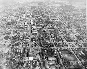
By 1950, Raleigh’s population had grown to about 70,000 and there was significant development outside the city’s downtown area. However, as the photo shows, most of the grid-like development is still centered around the downtown area and there is less urban density and even patches of green areas around the outer perimeters of the city.

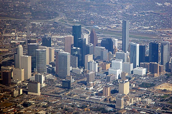
Finally, all of Raleigh has undergone major changes in recent years to reflect modern planning concerns, as well as the city’s population of more than 400,000 residents. However, despite the many changes, it is easy to see the influence of the grid-like land use perimeters that were marked out in the 1872 plan.
This concludes a few of my reflections for this week. Thanks for reading!
.
